
Sunday, April 5, 2020
Goose FIGHT!!!
Thursday, May 10, 2018
We Did It Again!!!
13.5-Mile 500 Mini-Marathon [see map] [video below]
After a 8 year absence Kelly & I completed our 5th Mini-Marathon together. With a new hip(2012) for me, and both of us being 7 years older, and little preparation by either of us, we had little expectations and goals in this year’s marathon. As it turned out we did finish the mini without any disasters, and for the first time since 2007 we finished together.
- 2007 Actual time: 3 hours 21 min. [Kelly & Glenn]
- 2008 Actual Time: 3 hours 24 minutes [Glenn]
- 2008 Actual Time: 3 hours 31 minutes [Kelly]
- 2008 Actual Time: 3 hours 15 minutes [Glenn @the Geist Mini]
- 2009 Actual Time: 3 hours 37 minutes [Kelly]
- 2009 Actual Time: 3 hours 57 minutes [Glenn]
- 2010 Actual Time: 3 hours 42 minutes [Kelly]
- 2010 Actual Time: 3 hours 46 minutes [Glenn]
- 2018 Actual Time: 4 hours 3 minutes [Glenn & Kelly]


-click arrow to start/restart video-

|
2008 From Static Pictures |

Tuesday, July 4, 2017
Day 1: Arkansas
Beginning Mileage: 133,400miles
Todays miles: 146
YTD Miles: 146
Major Rivers Crossed: Mississippi, St. Francis, Current
I left Troy’s in Poplar Bluff Missouri for Arkansas, destination Piggott. Arkansas seems to have limited attractions (this week: Diamond Mind and River float) so I may owe the state another visit. This leg of the road trip starts in from SEMO (southeast Missouri) and heads west/southwest from there, putting most of Arkansas in the opposite direction.

It lies near the Arkansas/Missouri state line, which puts the town as prime candidates for what was sometimes referred to as 'runaway wedding towns'. A town where less restrictive marriage laws on their side of the state line made them destination for lover's on the other side of the state line. Some runaway towns even had a certain appeal to residents within the town's own state even though the lax laws of the state applied to them statewide. Ministers or justice of the peace who "didn't ask a lot of questions" were well known in these border communities, which made them appealing to even an in state elopement.
Almost half of the ten sets of aunts and uncles that lived in Missouri were married in the small town of Piggott, Arkansas even though no one in the family ever lived in Arkansas. Dad said that he and mom went to Piggott to get
 married because Arkansas didn’t have a three day waiting period to (license to ceremony) get married. In talking to a librarian at the county library I found out that the town did have a Justice of The Peace who was known as the ‘marrying judge’. It would be interesting to compare the marriage license of our aunts and uncles to see if they all caught the same judge. I visited the county library in the hopes of researching the family marriages there, but they have had little research done on that period of time. The only record was for the marriage of Uncle Les and Aunt Evelyn.
Any hopes of seeing where our aunts and uncles were married some 80 years ago were dashed when I discovered the old courthouse was torn down and replaced about 20-30 years ago.


CLICKING THE PICTURES SHOULD ENLARGE THEM

Next stop is Tunica Mississippi, but spent first night at the T.O. Fuller State Park across the state line in Memphis, Tennessee.
This post is from my 49 State Road Trip Journal. Once the Journal is complete it will be migrated to this Blog (KGEA). Until then you can view that Journal by clicking here.
Natchez, Mississippi:


Natchez on the Hill


Friday, September 9, 2016
GRAVE IN THE MIDDLE OF THE ROAD.

- William was the great-great-great grandson of Pocahontas and John Rolfe. William, died by drowning in the Ohio River 13 years after her death.
Nancy passed away in 1831, and in keeping with her wishes, William buried her at what was apparently one of her favorite places; a hill with a beautiful view overlooking the creek. Nancy was the first to be laid to rest there, but before long, other locals were buried there and a cemetery grew around Nancy's grave.

Over time a foot path developed through this small cemetery and in the 1900s a county road was planned through it. Johnson County officials decided to build County Road 400 right through Nancy’s grave site. When workers arrived to move Nancy’s remains in 1905, local historians say they were greeted by her grandson, Daniel G. Doty, standing vigil with a shotgun in hand.

- Daniel was the son of one of Nancy's daughters, also named Nancy, the eighth of her 11 children. The second Nancy was 20 years old, if records are correct, when she married John Doty in Johnson County in 1843. Daniel was the second of her nine children.
For weeks, Daniel stood vigil, defending Nancy's final resting place, until every road worker was too terrified to cross his path. At this point, the county relented, and simply split the lanes right down the middle and worked around the plot. The county placed a concrete slab above the grave to protect it from inattentive drivers, and in August 1912, it was officially granted a historical marker, presumably to keep people from asking why the heck there was a giant hill in the middle of the road.
The other graves in the cemetery were moved, but I found no record of where they were moved to. There are three visible cemeteries within a mile and a half of Nancy's.1 The closest one was about a half mile west of Nancy's grave setting back from the road, This is the Armstrong Cemetery.2 While visiting one of the other two cemeteries a woman told me that the Armstrong Cemetery is where the other graves around Nancy were moved to.


The cemetery is also known as: Anderson and Israel Cemetery. There are three Armstrongs, two Israels, and no Andersons buried there, and no surnames that relate to Nancy's story. On the other-hand, of the 60 graves in this cemetery all predate the moving of graves from around Nancy and none of them predate Nancy's burial in 1831. The earliest tombstone date is 1834, three years after Nancy death, so all the graves in Armstrong 
Another Intrusion on Nancy’s Grave:
In May of 2016 Indiana Road Crews and Archaeologist closed of East 400 South to temporarily exhume Nancy's remains and repave the road.
Archaeologist Chris Schmidt and his students will move Barnett's remains temporarily and do some tests on the remains. Later this month, crews will rebuild and lower the burial mound, widen the road and build a new protective barrier for the 185-year-old grave. When that's done, Barnett will be returned to her resting place. The site has been the victim of traffic accidents over the years. The goal is to make the grave safer for drivers and Barnett's memory.
The two-lane country road was built around what historians had mistakenly believed was Barnett's solitary grave. The excavations have now revealed that there were 7 sets of remains under the road. These remains are probably from unmarked graves that were overlooked in the 1905 relocation.
The recovered bones are being kept at University of Indianapolis in a secure facility. County commissioners voted to pay for DNA analysis on the bones and on Barnett’s living descendants for comparison. They expect the testing will cost about $6,000.
When the tests are done and the road work is complete, the seven sets of remains will be placed in new coffins and respectfully reburied in the mound overlooking Sugar Creek. 
| Location: E. 400 S., Franklin, IN From Franklin, 5.5 miles south on US Hwy 31, then a little more than one mile east on E. 400 S. From Edinburgh, a little more than four miles north on US Hwy 31, then a little more than one mile east on E. 400 S. HOW TO MOVE A GRAVE: http://www.indystar.com/picture-gallery/news/2016/05/11/how-to-move-a-grave-in-the-road/84237014/ |  |

by GlennDL
Sources:
- IndyStar reporter Vic Ryckaert
- Kelly Wilkinson/IndyStar
- http://www.roadsideamerica.com/
- http://www.findagrave.com/index.html
- Indianapolis Star
- http://www.roadsideamerica.com/tip/462#sthash.vpDomMX4.dpuf
1There are actually at least 5 within a short distance
2There is no signage, I later found it on the Find A Grave websites map.

Wednesday, July 13, 2016
Fort Defiance, Lewis & Clark: The Confluence of the Ohio & Mississippi Rivers
After the family returned from Germany and moved to Indianapolis, Indiana there were primarily three routes to make the trip from Grandpa John’s house (East Prairie, Missouri):
- The most common route was to take highway 62 (two lanes) and cross the Mississippi River into Cairo, Illinois using the Cairo Mississippi River Bridge and then take the Cairo Ohio River Bridge (highway 51 bridge over the Ohio River to Wickliffe, Kentucky) following two lane highways and roads through many small towns in Kentucky and Indiana.
- Before the building of the above bridges the primary route would be similar except the crossing would be by river ferry. Today there are at least two river ferries operating across the Mississippi River between Memphis, Tennessee and St. Louis Missouri: The Dorena Hickman Ferry and the St. Genevieve Ferry.
By Chris Light at English Wikipedia, CC BY-SA 3.0, https://commons.wikimedia.org/w/index.php?curid=16994966The height of the bridges, the long approach, occasional state of disrepair, the very narrow two-lane deck, and the sight of heavy barge traffic passing underneath the bridge can all contribute to an eerie sense of trepidation as you approach the bridge. This can quickly turn to a scary ride when you encounter tractor trailers coming from the other side. Tractor-trailers account for 1/4 of the 3500 vehicles that cross the bridge daily. At different times in their history the two bridges have been on several most ‘scariest’ or ‘dangerous’ in America bridge list.
In the years since the construction of the two bridges, the town of Cairo has experienced an 81% population decline (1930 to 2010), the most dramatic decrease of any principal city in the United States.[3]The bridges initially played a part in the town's demise as the ferry and railroad industries were severely impacted
- In 1978, the multi-lane Cairo I-57 Bridge was completed less than five miles upstream, bypassing Cairo (contributing to its further decline). Using the new bridge and the the interstate system involving Interstate 57 north to Effingham, Illinois and then taking Interstate 70 east to Indianapolis. This quickly became the most common and quickest route.
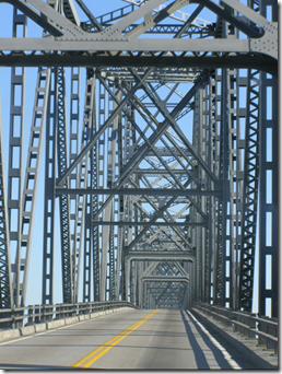

The Interstate route was originally a big time saver, but with the increase in connecting Interstates, the Kentucky Parkway system and efforts to extend Interstate 69 from Indianapolis southward, pretty soon I-57/I-70 will be neither the quickest or most scenic. I tend to mix my routes up using both ferries and bridges on occasion.
All three routes have their appeal; the ferry for its charm, I-57/I-70 for its quickness and abundant amenities, and the Highway 62/51 for the scare and Ft. Defiance.
Cairo is located at the confluence of the Ohio and Mississippi Rivers. With the confluence Cairo is situated on the southernmost tip of Illinois on a peninsula formed by the two rivers. On the very tip of this ‘peninsula’ you can stand between the two rivers, in Illinois and see Missouri and Kentucky. Also on this tip is Fort Defiance Park.
GlennDL
Here you can witness the awesome coming together of two great rivers, the Mississippi and Ohio, and the beginning of the lower portion of the mighty Mississippi River. The park contains a 2 story observation deck and you can go right down to the point of confluence at the rivers edge2 |

"On November 14th 1803 at the Confluence of the Ohio and Mississippi rivers the corps of Discovery stayed for 6 days. One of the longest stops made by the expedition. Here they saw the Mississippi for the first time, noted the mistletoe on the large Timber and to their surprise caught a 128 lb blue catfish. They're staying allowed Captain Lewis to teach Captain Clark the use of the navigation equipment (compass and sextant). Because of the third principal Meridian begins at the mouth of the Ohio astronomical observations at this point were crucial."1
"…Many of the men who enlisted in the journey were from Illinois, and the group spent five days in mid-November 1803 at the confluence, gathering data and beginning the process of mapping the river route to the Pacific Ocean.”
At that time, the confluence was the furthest location in the west that had been accurately mapped and for which longitude and latitude were known.”
"Because the geographic location near present-day Cairo was such an important landmark, and because Lewis and Clark had just joined together several weeks earlier, the confluence became the place where they trained each other in their respective skills – Lewis with celestial navigation and Clark with land surveying," Swenson said.
“In addition, international politics at the beginning of the 19th century centered on the area, as the new states, England, France and Spain competed for land, resources, trade and military advantage.”
“The confluence of the Mississippi and Ohio Rivers today is actually about two miles south of its 1803 location. Project leaders agreed that placing the sculpture at the current confluence is most appropriate as it matches the scene described in William Clark's first map of the entire expedition…."2
1 on site marker
2 From November 8, 2005 SIUC & Cairo remember the past:Lewis & Clark sculpture dedication set for Nov. By TOM WOOLF <http://www.cairogate.com/news/articles/2005/fort_defiance_dedication.html>
From <https://en.wikipedia.org/wiki/Cairo_Mississippi_River_Bridge>
From <https://en.wikipedia.org/wiki/Cairo_Ohio_River_Bridge>
From <https://en.wikipedia.org/wiki/Cairo_Mississippi_River_Bridge>
http://abandonedonline.net/2012/02/13/a-trip-to-cairo-illinois/
*There is a story floating around about a student pilot that flew a loop around the Cairo Mississippi River Bridge in 1956. While the story is not confirmed, many people who were stationed at nearby Malden Air Base at the time have recounted these events. A student pilot flying a T-28 trainer was obsessed with the idea of flying a loop around the Cairo highway bridge. Once day, after spending many hours studying the problem, he found himself flying in the area alone. He decided that today was the day. After taking a pass to make sure that there was no barge traffic in the area, he flew out a few miles to line up his flight and gain some speed. Unfortunately, he picked up a little too much speed. He flew under the bridge OK, but by the time he pulled up into the loop, he was well beyond the bridge. As he went inverted, he could see that he would come down right about where the bridge was. If he tried to tighten up the loop, he might have hit the bridge. If he tried to lengthen the loop, he might stall and crash into the river. As it happens, he just cleared the bridge, so he pulled back hard to start to pull up under the bridge to finish the loop. By the time the airplane started to climb, he had hit the water, damaging the skin on the wings and about 12 inches of the outer tips of the propeller. He flew back to the air base, parked the airplane, and wrote it up as having a rough engine. Officials at the base figured out what had happened, and the cadet was ejected from the flight training program.
From <http://www.johnweeks.com/river_mississippi/pagesC/umissC12.html>
Tuesday, May 12, 2015
Featured Trail: Ft. Harrison SRA
| |||||||||
| |||||||||
| -click arrow to start/restart slide show- | |||||||||
| |||||||||
|
|


Thursday, February 26, 2015
Cruising: My Favorites
Best on shore excursion:
- Dunn's River Falls, Ocho Rios, Jamaica: Phil Lafayette
- Zip-Line Canopy Tour, Roatan, Honduras
- Jet Ski, Coco Cay Island, Bahamas: Royal Caribbean [Sorry, no pictures.]
- Sting Ray City, Grand Cayman Island: Native Water Sports
- Stewards Cove Snorkeling, Bahamas: Swimming with the sharks
- Tubing White River, Ocho Rios, Jamaica: Phil Lafayette
- White Water Rafting, Limon, Costa Rica
- Panama Canal Excursion, Colon, Panama
- White Knuckle Thrill Ride, Key West, FL.
- Gatorland, Orlando, Florida
- Three Reef Snorkel, Cozumel, Mexico
- Mayan Cave Tour, Belize
- Port Calica, Mexico: Lagoon Snorkeling, Ceynote Snorkeling, Swimming with the Sea Turtles, Zip Line
- ATV Jungle Adventure, Cozumel, Mexico
- Jungle Queen River Boat, Ft. Lauderdale, Florida
- Ruins of Tulum, Cozumel, Mexico
Best Entertainment:
- Holiday [Carnival]: Multi talented Cruise Director was surprisingly talented. Great floorshow and comedians.
- Freedom [Carnival]: Great floorshow and comedians. Big Screen TV on Promenade Deck
Best Food:
- Sovereign of the Seas [Royal Caribbean]: The buffet seemed to always be open, variety & flavor
- Shockies, Ocho Rios, Jamaica: Jerk Pork, Chicken and Festival Bread
- Jungle Queen River Boat, Ft. Lauderdale, FL: Chicken, Ribs, Cole Slaw [not to thrilled with the Shrimp though]
- Rays Rum Point, Grand Cayman: Hot Wings and Fries
- Freedom [Carnival]: But do you not have a burger on the room service menu?
- Triumph [Carnival]
Best Bingo:
- MS Holiday [Carnival]: c’mon Becka… When this girl inevitably makes Cruise Director the world of Bingo will suffer a great loss, and I’m not just saying that because We won on the first three days of the cruise.
- Freedom [Carnival]
- Sovereign of the Seas [Royal Caribbean]
- Triumph [Carnival]
Best Casino:
- Sovereign of the Seas [Royal Caribbean]: Live dealer at the Texas Hold’em table, daily hold’em tournament. Carnival and their electronic ‘Poker Pro’ is more like staying home and playing on the internet than being in a Casino.
Best Ship:
- Sovereign of the Seas [Royal Caribbean]
- Freedom [Carnival]
- MS Holiday [Carnival]
- Triumph [Carnival]
Friday, January 30, 2015
Chicago and Los Angeles: Amtrak 2012
IL, MO, KS, CO, NM, AZ, CA
Take in the Grandeur of the American West on an Adventure between Chicago and Los Angeles

The Amtrak Southwest Chief runs daily between Chicago and Los Angeles, through the vast expanse of the fabled American West.
You'll be mesmerized by this region's beauty and allure. We'll take you across the mighty Mississippi through eight states—past wheat fields and ranches, missions and pueblos, mountains and deserts. Carving through curving canyon passages only a few feet wider than the train itself, you'll see spectacular landscapes and pristine vistas not visible from interstate highways.
2012 trip to and from Los Angeles for 2012 APWU National Convention.
Monday, January 26, 2015
Bear Encounter: Behind the scene visit at the Indianapolis Zoo.
-click the arrow to start/restart video-
| Since these videos and pictures were taken both Kodiak bears have died. Both were already advanced in age when the Indianapolis Zoo received them as in one clip you can hear the trainer talking about how one of them sometimes has bad days and doesn't want to leave the indoor enclosure. |
Tuesday, September 30, 2014
2014 Kayaking on White River (Yorktown-Chesterfield, Indiana):
Kelly McKinney MAP IT
18 hrs · Edited ·
Allowed on Timeline
Yesterday my dad and I went on a four hour kayaking trip down the White River. It was a beautiful day and I had a great time! It also happened to be the 2 month anniversary of his hip replacement surgery. Would highly recommend it to anyone. The company offers Groupons often and provides everything that you need.

Sunday, June 22, 2014
Cataract Falls: updated 2014
2007 -- Visited during something of a drought so the water level was pretty low, Little Sister Falls was bone dry (it is a little spring fed falls that has some visual appeal even dry). Got some great pictures until I fell in the water and soaked two cameras (see the note below on drying out electronics). That and time constraints kept us (Troy, Kelly and I) from getting any pictures from the covered bridge.
2014 – Visited with Tracy, Sierra and Shilyn after doing the McCormack State Park ‘Volkssport’ walk. The water levels were higher than in 2007. Ignore the dates on the picture, it defaulted to 2007 when I changed the batteries.
Visit the Cataract Falls website at: http://www.cataractfalls.com/
There are three falls; upper, lower and Little Sister. There is a trail between the upper and lower falls, but you can also drive. All three falls are in walking distance of each other.
Thursday, August 30, 2012
Pictures from 2nd trip to LA.
This trip, like the first, was to attend my unions National Convention.
Still not impressed with downtown LA. I can’t say I’m fond of LA. The downtown is as dead as Naptown in the 70s. If you like beggars dressed better than you every half-block and $8 hamburgers you might like it.
On the first trip I took the subway/tram from downtown to the airport and it provided more interesting sights than downtown LA, but everything is so spread out. The subway took me trough Compton and by other known sites.
I planned on renting a car and adventuring to several attractions (Baldy Mountain, Catalina Island), but when my back went out I ended up having to cancel everything. California
Thursday, April 14, 2011
Panama, Colon: Panama Canal Excursion
2011 Carnival Freedom Cruise to Colon, Panama. After a bus ride from Colon, Panama on the Caribbean Coast to Panama City on the Pacific Coast we took the Panama Canal Excursion from Panama City through the Miraflores and the Pedro Miguel Locks, the Gailard Cut, the Centenary Bridge to Gamboa for our bus ride back to Colon.


More 2011 Cruise Adventures:
Subscribe to:
Posts (Atom)